Hiking the Himalayas in Himachal Pradesh
The Grand Indrahar Pass, Himachal Pradesh

The hiking expedition lets you experience the Dhauladhar range and Pir Panjal Mountains. The hiking trail is moderately difficult. On the way you hike through green pastures and navigate through dense forests. These are Deodar and Rhododendron jungles, and if you have never been to a tropical forest, then this could be an enchanting experience. You also trudge on the ancient Gaddi Shepherds trail.
Hiking through this pass is an amazing experience. You can see the Mani Mahesh Kailash peak. The snow clad Panjal Range will never cease to delight you. The best time to visit this place is between May and October.

Trekking in Manali, Himachal Pradesh

Manali is the epicenter of adventure in Himachal Pradesh and is one of the top hiking destinations in India. There are numerous things to do and see here. Be it adrenaline pumping outdoor sports, or experiential hiking trips, Manali has all the options. The best place to start hiking in Manali is the Solang Valley. It is also called locally as Snow Point. You can trek up to this point or take a public bus.
From Snow Point, you hike up to Dhundi passing naturalistic settings along the way. You can engage a local guide to help you get to the place. Along the way you will see the Beas River. The mountain water is icy cold on most times of the year. Purple Rhododendron flowers stand in an inviting stance throughout the hike. The Solang Valley hike in Manali is the most engaging and enlightening hiking destinations of them all.
There are some popular day hikes in Manali. Some of them are Bijli Mahadev and Dashaur Lake. The former is a trek to Bijli Mahadev and back. The latter is a 5 km trek from Manali to the Dashaur Lake and back. For first time hikers, a day hike is recommended. And Manali presents so many options for the same.
Seven Sisters Trek, Himachal Pradesh

.jpg?w=753&h=450&dpr)
- 5D/4N
- 5D/4N
About Hampta Pass Trekking
Hampta Pass trek is one of the most picturesque adventure in the Indian Himalayas that takes you through the lush green valleys of Kullu to the rocky, barren landscapes of Lahaul and Spiti.Thrillophilia’s Hampta Pass trek packages offer you to embark on a journey that gives you an essence of the true beauty of mountains.
Our all inclusive packages include all the travel arrangements starting from accommodation in hygienic campsites, transportation to and from the trek’s base camp and healthy meals. Thrillophilia operates the treks through a vast network of trusted tour operators who know bits and pieces of the journey, in depth. The highly experienced trek leaders guide you throughout the journey and often take you to offbeat places to soak in the best views.
The Hampta Pass trek route begins from the quaint village of Jobra from where you hike towards your campsite in Chika. The next day, start ascending towards Balu ka Ghera which is nestled amidst the alpine meadows and surrounded by the gigantic peaks all around. You will be rewarded with beautiful views of the snow-covered peaks and witness the terrain changing from meadows to boulders. You will then commence the final leg of your journey to reach your destination- the Hampta Pass, situated at an altitude of 14,000 ft. Spend some peaceful time there in laps of the Himalayas.
After exploring the remote village of Hampta, proceed to descend towards Chatruwhich is one of the main highlights of the trek. It is the junction point of the roads to Spiti Valley, Rohtang Pass and Hampta Pass.
So what are you waiting for ? Pack your rucksacks, tie up your trekking shoes and get ready for a life-changing journey through the deep gorges, lush valleys and rocky trails of upper Himachal.
Quick facts about Hampta Pass Trekking:
Start Point/End Point: Manali Base Camp
Duration: 4 Nights & 5 Days
Hampta Pass Trek Height: 14,100ft
Hampta Pass Trek Difficulty Level: Moderate
Trekking Distance: 35kms
Best time to do Hampta Pass Trek: Mid June - September
Hiking the Himalayas in Uttarkhand

- 6D/5N
- 6D/5N
- In winters the sky is usually absolutely clear and the air clean ensuring fantastic views. At an altitude of around 3800 m/12500 feet, the summit (Kedarkantha) offers a good challenge to trekkers who are rewarded for the hard work with mesmerising views which are sure to stay with one, lifelong.
- Days are going to be warm and sunny but be prepared for cold nights with temperature always being sub-zero.
If luck is taking the trip with you then get ready to be enthralled by spotting wildlife of the region. There are leopards, wild cats, birds, bear, boars and the musk deer to be seen.
- There is also a policy of ‘Safety first’ and in line with this have chosen campsites which have back up Gujjar huts so just in case the weather gets really bad these huts can be used providing utmost safety.
- The trek starts with an easy climb to a beautiful water pond called Juda-ka-Talab, continue a short distance beyond the pond to our camping site for the night and get acclimatised to the conditions.
- By the end of the day, start seeing the snow-covered peaks of the Himalayas including some peaks that stretch into the Himachal region.
- The next day starts with climbing and gaining altitude and trek through snowfields towards the base of Kedarkantha. The ease or difficulty of today’s hike will depend on the snow conditions, after great hiking day and camp at the base.
- The next day, you move as early as possible to try and get maximum time for the climb to the top.
- From the top get brilliant views from all around, the Himalayan ranges and the underlying valleys make quite a sight. Equally enjoyable as the views are going to be the sense of achievement that one experiences on climbing a snow-clad Himalayan mountain.
- Next day get down to Sankri early and celebrate the successful summit of the Kedar Kantha peak. From Sankri, drive down to Dehradun next day.
Temperature: Day: 8°C to 15°C and Night: -5°C to 3°C
Kedarkantha Trek Distance: 20 KM
Maximum Altitude: 12,500 ft
Kedarkantha Trek Difficulty Level: Easy To Moderate
Railway Station: Dehradun is the nearest railway station
Airport: Jolly Grant Airport, Dehradun
Base Camp: Sankri (10 hrs drive from Dehradun)
ATM: Purola has the last ATM point before your trek begins.
How to reach?
Dehradun has a railway station which is well-connected from all metropolitan cities and the nearest airport is Jolly Grant Airport, Dehradun.

- 6D/5N
- 6D/5N
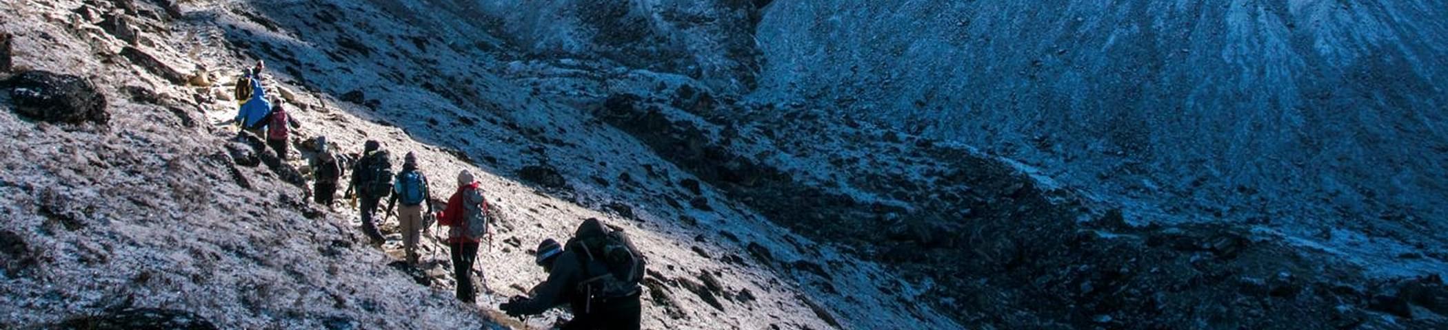
About the Kuari Pass Trek:
A top winter trekking destination in India, the Kuari Pass Trek is tucked away in the gorgeous Garhwal region of the Himalayas. This trail, also known as the Lord Curzon trail, is situated at an elevation of 12,516 feet and offers both historical value and breathtaking natural scenery.
You can experience the vibrant local traditions of Uttarakhand as you travel through villages of Tugasi, Guling, and Khullara with the Kuari Pass trek package. The Pangarchulla, Chaukhamba, Neelkanth, Dronagiri, Hathi Ghoda, and Nilgiri mountain ranges are among the breathtaking sights that can be seen from the trail.
The spectacular vista of the Nanda Devi Massif, which provides an amazing backdrop for stargazing, is the trek's high point. With an easy to moderate difficulty level, the Kuari Pass trip is suitable for both novice and seasoned hikers.
You may come across the paw prints of snow leopards and Himalayan bears throughout your walk, offering a unique look into the local wildlife. The span of November-March is the best time for Kuari Pass trek because of the perfect weather that makes for an unforgettable experience.
Departure Dates (2024)
November: 3, 9, 11, 16, 17, 23, 24, 30
December: 1, 7, 8, 10, 13, 14, 15, 18, 19, 21, 22, 23, 24, 25, 26, 27, 28, 29, 30, 31
January: 4, 5, 6, 11, 12
Kuari Pass Trek Quick Facts:
- Duration:6D/5N
- Kuari Pass Trek Distance: 33 km
- Kuari Pass Altitude: 12,516 ft
- Difficulty Level: Easy To Moderate
- Kuari PassTemperature: Day: 13°C to 18°C and Night: -3°C to 4°C
- Best time for Kuari Pass Trek: March to mid-June & mid-September to early November
- Railway Station: Haridwar is the nearest railway station
- Airport: Jolly Grant Airport, Dehradun
- ATM: The last ATM is available in Joshimath
- Start-End Point: Haridwar
Doon Valley Trek, Garhwal, Uttarakhand

Hiking in Garhwal is always an exhilarating experience. You trek through flower meadows and thick forests. The Har Ki Doon Valley presents you with varied flora and fauna. Hiking through the Har Ki Doon Valley is a 50 mile trip. It is only for trekkers who like to hike in fair weather conditions. You will hike through a steady gradient in the valley and is relatively easier compared to Himalayan trails where you have to navigate from one valley to the other.
Geographically it is located in the Garhwal Himalayas, the Har Ki Doon valley is cradle shaped but you cannot see its shape when on the ground! There are numerous snow covered peaks in this place. The alpine vegetation is one of the prime attractions in these regions. The valley is snow clad throughout October to March which is generally avoided. The hiking trails through this valley pass through remote villages such as Gangaad, Seema and not to forget Osla which is an overnight camping spot.
On the way you will encounter the Tamsa River. If you are hiking here during the monsoon season, this river is swollen and flows at full capacity. Further into the trail, it bends into gorges and deodar forests. You can choose to stop at Torluka, stay at the Forest Rest House or the accommodation provided by the Garhwal Mandal Vikas Nigam. From Torkula, the trail gets tougher. You will have to navigate through this rugged terrain to ultimately reach Osla.
Clouds End Trek, Mussoorie, Uttarakhand

The surrounding area is spread over more than 2000 acres offering plenty of avenues to experience some of the best hikes in India. There are thick oak and deodar forests spread across the area. There are numerous species of flora and fauna that exist here. Camping here brings you back to living in a bygone era. If you are looking for a complete lifestyle overhaul for some time, then this is the place for it. Apart from hiking, you can also do horse safaris, and numerous other adventure activities.
There are plenty of activities that you can do here. You can climb a hill. Walk among deer. Try to entice a pheasant. You can setup a perch point and look at the Himalayan snow peaks that stretch for a distance of 250 kilometers. You can hike up to the Jwala Devi Temple. You can head off into the Benog Mountains to see quails. From here you can see the estate of George Everest. There are so many activities to do here that this place befits a mention in the top hiking destinations in India.

- 2D/1N
- Dehradun
- 2D/1N
Quick facts about Nag Tibba Trek:
- Nag Tibba Temperature: 14 to 22 degrees (days) and 6 to14 degrees (nights) between September and December and 16 to 25 degrees (days) and - 8 to 16 degrees (nights) during other months
- Nag Tibba Trek distance: 15 km
- Maximum Altitude: 9,910 ft.
- Starting and Ending Point: The trek to Nag Tibba starts and ends at Dehradun/Delhi depending on the variant you choose.
- Nearest Railway Station: Dehradun is the nearest railway station
- Nearest Airport: Jolly Grant Airport, Dehradun
- ATM: You will find ATM's in Mussoorie and Naianbagh.
- Nag Tibba Trek Difficulty Level: Easy

- 5D/4N
- Haridwar
- 5D/4N
About The Deoriatal Chandrashila Snow Trek:
To be spellbound by the natural splendour of the Garhwal Himalayas, take a snow trek to Deoriatal Chandrashila Snow Trek along with Chopta trek, that offers you the best of trekking in Uttarakhand. Not only will you get a chance to surpass breathtaking pastures laden with snow, anyone can take this trek due to the easy terrains and comfortable trails. The first bit of the trek comprises a walk up to Deoria Tal Lake at 7999 ft surrounded by dense thickets all around. This trail does not comprise of much snow which explains the easy start to the trek. The sight of the lake reflecting the mighty Chaukhamba Peak, located nearby, is a vision worth marvelling at.
The next bit of the trail is the hike up to Chopta peak laden with beautiful blankets of snow in winter. Upon arriving at Chopta peak, marvel at the expanse of snow surrounding the environs. Due to the snow conditions, either camp will be set up or arrangements will be made in some homestays dotting the area. There is also the trek to Tungnath temple at 12074 ft, known to be the highest Shiva shrine in the world. This trail offers magnificent views of Bandarpoonch, Kedar and Chaukhamba peaks. After a 1km long trek from Tungnath is the top of Chandrashila peak at 13123 ft that gives a panoramic visual on the gorgeous valleys and snow-peaked mountains around.
Adding to the serenity of this expedition is the experience of residing in the charming lodges in Kund that overlooks the Mandakini river under the Kedar peak.
Quick Facts:
Maximum Altitude: 13,123 ft
Temperature: Daytime: 8°C to 15°C; Night time: -5°C to 3°C
Difficulty Level: Moderate
Starting and Ending Point: The trek starts and ends at Haridwar
Railway Station: Haridwar is the nearest railway station
Base Camp: Kund

- 7D/6N
- Dehradun
- 7D/6N
About the Destinations:
Nestled away in the heart of a cradle shaped valley, the trek to Har Ki Doon valley is known to be one of the most stunning and picturesque treks in Uttarakhand Embraced with scenic alpine meadows and striking greeneries, the beauty and splendour of this portion of the Garhwal Himalayas is credited by snow clad peaks, panoramic views of the Himalayan Range, gurgling rivulets and much more.
Locally known as the 'Valley of Gods', trekking through this eternal meadow is one of the best experiences and is rewarded with mesmerising views of the glaciers, mountain ridges, ancient temples, appealing caves and high altitude villages. According to the legends, Har Ki Doon valley shares its history with the age of the Mahabharata and holds an important place in the Hindu mythology.

About the Roopkund Trek:
The "mystery Lake of Uttarakhand" - the Roopkund Lake - is a must-do trek for an avid trekker. The Roopkund trek is a moderate trek, with a beautiful view of mountainous rivers, enthralling ridges, lush forests, and scenic meadows around. The trek starts from Lohajung and takes you through a high altitude of 16,499 ft., during which you can spot Bedni Bugyal, the quaint villages of Wan and Didna. The zig-zag and snowy trail offers the best views of the Roopkund lake, Neelganga river, and also offers a memorable experience of meditating at the Kalu Vinayak temple.
Do not forget to notice the royal twin peaks of Nanda Devi, Kamet, Dronagiri, and Hathi- Ghodi Parvat and spot the rare-yellow Himalayan magpie.
Hiking the Himalayas in West Bengal
Tiger Hill, Darjeeling, West Bengal

It is from Tiger Hill that you can view the majestic contours of the Himalayas and Mount Kanchenjunga. If you tread all the way to Tiger Hill, be ready to be treated with breathtaking views. The magnificent sunrise and sunset views provides a perfect photography spot. March and June is the perfect time to visit this spot. During this time Tiger Hill is frequented by hundreds of people to experience one of the best hikes in India. In fact thousands of people climb the hill during this time every day.
You should try to get here by pre-dawn to witness the sunrise. During this time, the mountains are painted by the sun’s rays in vivid colors such as yellow, pink and purple. After witnessing the splendid sunrise, you can hike to Ghoom – which is a scenic town. On the way you can see beautiful tea plantations that will amaze you to no end.
Singhalia Ridge Trail, Darjeeling, West Bengal

Experience the Singhalia Ridge Trail in the heart of a beautiful city, Darjeeling in any month other than July to mid-September. During this time, this park is not open for the public. Darjeeling is one of the picturesque destinations in the country. When you get here, you will be amazed at the plenitude of options available. Whether it is to take a break from the hot summer season or to conduct hiking activities, the fringes of the Himalayas have plenty to offer.
There are immense number of activities to do in Darjeeling including hiking, mountain biking, ride in a Toy train etc, that are really awesome and the breathtaking views of Darjeeling are the treat to eyes that will you a baggage full of beautiful memories.
The most popular is the Singhalia Ridge Trail. If you are staying while in transit through the trail, you must make advance bookings in Darjeeling for accommodation. This hiking trail in Darjeeling is the most adventurous and exciting of them all. You take this trail only if you are willing to expend some thrills on the way. Local guides have expert knowledge on how to navigate the trail without a hitch.
Darjeeling to Kurseong Trek via Old Military Road, West Bengal

The Darjeeling to Kurseoung trail via the Old Military road is considered one of the top hiking destinations in India. This is essentially a one-day hiking trail. Due to this, it is a very popular one amongst first-time hikers. The expedition starts off in the picturesque settings of Darjeeling and ends at Kurseoung.
The Old Military road is an amazing sightseeing route to take. One point of interest is the Mag-Dhog Yolmowa Buddhist Monastery. Also known as Aloobari, this monastery was built by Sri Sangay Lama. Construction of the monastery began as early as 1914. This was the same year that the First World War erupted. Hence, the monastery got the name Mag-Dhog – which means avoiding war.
Apart from the monastery, the coffee plantations are worth a visit. These plantations stretch over several acres of land and offer one of the best hikes in India. These sloping lands have narrow passages for people to walk through. Along with coffee plantations, there are plenty of tea estates as well. These sprawling tea estates give off the aroma of tea leaves.
The freshness of the air is unmistakable. You will feel like you are in one of purest environments on Earth. One of the reasons to this is that the estate owners take special care that the environment that these plants grow in is pure and verdant.
Hiking the Himalayas

- 9D/8N
- 9D/8N
About Chadar Frozen River Trek :
The Chadar Trek, also known as the Zanskar River Chadar Trek, is a thrilling winter adventure over the frozen Zanskar River in Ladakh, India. This spectacular journey takes trekkers through breathtaking landscapes of icy cliffs and snow-covered mountains. Starting near the village of Chilling, the trek unfolds the mystery of the Himalayas as adventurers navigate the frozen river, experiencing the unique challenges and beauty of the region. With temperatures dropping significantly, the trek requires careful preparation and endurance but rewards participants with an unforgettable experience amidst the untouched wilderness of the Zanskar region.
Departure Dates:
➔ Jan '25: 5th, 7th, 8th, 10th, 12th, 16th, 18th, 20th, 25th.
➔ Feb '25: 1st & 2nd
Chadar Trek Quick Facts:
- Chadar River Trek Duration: 9D/8N
- Chadar Trek Distance: 62 km
- Maximum Altitude: 11,123ft
- Difficulty Level: Difficult
- Chadar Trek Temperature: -5 to -15 degrees (during the day) and -15 to -25 degrees (during the night)
- Chadar Trek Best Time: Early January-Early February.
- Start and End Point of the Trek: Guest House in Leh.
- Nearest Airport: Leh airport. (Kushok Bakula Rimpochee Airport)
- Last ATM: Leh Market and Airport.
How to Reach Leh :
By Air: The most convenient way to reach Leh is by taking a direct flight to Kushok Bakula Rimpochee Airport from New Delhi. This journey can take around 1 hour and 15 minutes and is offered by various airlines including SpiceJet, Air India, and IndiGo.
By Road: Delhi is approximately 930 kilometres and it takes around 24 hours to reach depending on the road conditions. You can take an HRTC bus from Delhi to Leh via Manali which takes approximately 30 hours to reach. Similarly, you can opt for a road trip to Leh from Delhi via NH 3 which can take around 25 hours depending on the route and halts.
Hiking the Eastern Ghats
Nagalapuram Trek, Chittoor, Andhra Pradesh

Nagalapuram Hills is a vast place spread over more than ten thousand acres. Here the trails run along streams. At all times you will be walking beside streams and jumping across them from boulder to boulder. There is another exhilarating trek that connects Nagalapuram and Tada. This is locally known as marathon in mountains given its difficulty level.
That is why Nagalapuram is one of the toughest hiking destinations in the country. But the difficulty in hiking is compensated from the sights that are on display here. The scenic charm of the place is outstanding. The mountains of Nagalapuram have so many scenic delights that they look straight out of an adventure travel movie.
Araku Valley Trek, Andhra Pradesh

Araku Valley is located between Vishakhapatnam and Hyderabad in Andhra Pradesh. This place is known for its verdant greenery and has some of the best hikes in India. There are plenty of hills, thick forests, and waterfalls in the Araku Valley. The valley is spread across an area of 36 kms. The valley is located on the Eastern Ghats of India. There are many ethnic tribes living in this area still.
The hiking trails in Araku are moderately difficult. When in transit you will see the tribal habitation and their culture in full display. Hiking routes take you through these tribal villages. Along the trail you can also see the Barezolla Park. Then there are the Bora Caves which is a popular spot. The Bora Caves to Katiki Water Falls hiking trail is a popular one too. In the Araku Valley that you will see the Jindhagada Peak. This mountain is the highest in Andhra Pradesh and is one of the top hiking destinations in India. There are separate hiking trails to this mountain and beyond.